Here in this analysis is used the German
version "Keine Posaunen vor Jericho" of DTV, Munich 2004,
second edition of 2005. All page indications refer to the
German version. I hope the page numbers are not very
different.
The real
kingdom of David: tiny dimensions in the highlands
Kingdom of David which is provable by
archeology goes from the southern part of the highlands
from the northern border of Negev and to the southern
region of today's Jerusalem. This kingdom of David was
only heavily accessible and hardly had agricultural
resources (p.148). Central highland from Jerusalem to
Hebron was stony desert in these times. Only step by step
this stony desert is liberated from it's stones and is
converted into fertile earth as it is today (p.149).
[The change from a stony desert to a
fertile plain happens only later by a hardship when the
big Empires are cutting more and more the little Reich
Judah].
In the kingdom of David
-- people are illiterate, shepherds and
farmers are mixed, there is no writtenness, and there are
no structures of any Reich (p.160)
-- it can be estimated that there lived
45,000 persons in the highlands, perhaps 40,000 in the
North, not in the South near Jerusalem (p.160)
-- the visit by queen Saba in Solomon's
house claimed in the Bible (1st book of Kings 10,1-10) in
combination with the country Ophier and far commercial
expeditions to Ezyon Geber (1st book of Kings 9,26) are
only possible 300 years later when the structure of Judah
had developed managing big commerce (p.161)
-- add to this - according archeology -
Ezyon Geber at the Red Sea has no population before the
"late time of the Kings" (p.161)
-- the construction of Thamar (1st book
of Kings 9,18) in the desert also is only possible 300
years later, and according to archeology has got a
population also only during the "late time of the Kings"
(p.161)
-- during Bronze Age and in the
beginning of the Iron Age the region is stony with tense
thicket and forests, farmland hardly exists (p.149)
-- at the time of the Jewish highland
villages (12th to 11th century B.C.) hardly 10 Jewish
settlements are found there (p.149)
-- the number of villages is rising step
by step, but the system of villages is the same also in
10th century B.C. (p.149)
-- in the North of the alleged South
Reich Judah are installed fruit and vineyard cultures on
the western slopes, in the territory of proper South Reich
Judah the soil is too stony (p.149)
-- according to archeology up to the
rule of invented Solomon the invented kingdom of David is
in complete isolation and is hardly populated by resident
population, is blocked in it's development without any
bigger urban settlement (p.149)
-- Jerusalem in these times of invented
David and Solomon is even no meeting point for Bedouins,
the site has no findings at all from this time (p.150)
-- according to
archeology appr. 20 little mountain villages can be
stated for the territory of Judah in the 10th century
B.C., with some 1,000 inhabitants, a big part of them
are shepherds (p.150).
No writing ability
in Israel Palestine up to the end of the 8th century
B.C.
Up to the 1990s philologists and anthropologists suppose
that there was a strong and fully formed state under the
kings of David and Solomon. But the Bible text about
Jerusalem describing Solomon and David in the 10th
century was probably written only to the end of the 8th
century B.C.,
-- because until this time there are no findings
indicating that there was a writing ability
-- because until this time there are no findings
indicating a statehood of Judah or Jerusalem (p.34)
-- a big Reich under David and Solomon from the Red Sea
up to Syria is not possible without knowledge of writing
and reading (p.150)
-- without army and without developed weapon production
such a big Reich would never be possible against the big
Empires of Egypt and Mesopotamia, there should be a lot
to be found when there had been such a weapon production
for such a huge Reich (p.151)
-- also remnants of a big administration of such a big
army are missing, and without such a big administration
rule of such an Empire with this dimensions under
Solomon is never possible (p.151).
Only since 8th century B.C. there can be stated a
scripture in both city states of Shechem (Bible says
"Israel) and Jerusalem (Bible says "Judah"), and it's a
common scripture (p.178).
[Inversion of
argument: with ability of writing and reading also
manipulation is possible now
As soon as the power of Jerusalem is big enough and
ability of writing and reading is spread enough, also
mass manipulation will be possible, which is executed by
invented OT.
There are other cases where the populations won the
ability of writing and reading and then suddenly were
manipulated into the ruin, with Mao in China and with
Lenin and Stalin in Russia].
945-924 B.C.
Egypt: Pharaoh
Shishak = Sheshonk I.
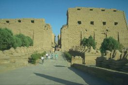
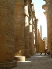
Pharaoh Shishak (Bible, first book of Kings, 14,25) is
identified as Sheshonk I from 22th dynasty in Egypt.
Pharaoh Sheshonk I is leaving a report of a military
campaign at the wall of Amun temple in Karnak in Upper
Egypt, but this text leaves open any speculation.
Clearing of this text only comes with precise
archaeological methods of date determination (p.28).
Amun temple in
Karnak
|

 Amun-temple in Karnak, outer front

 Amun-temple in Karnak, columns with inscriptions
|

Map with Karnak, Luxor, Thebes, Giza, and Cairo
on the Nile river
|
Assyria is
developing more aggression
According to excavations of towns, huge
palaces and archives of cuneiform writings in Asia Minor
the Empires with it's capitals Ninive (Assyria) and
Babel (Babylonia) are detected as aggressive (p.28).
Assyrian data
|

God Ashur, the supreme Assyrian god. Like him
all Assyrian rulers want to look like...
|

Clay
tables with cuneiform writing from Babylonia,
2000 to 1700 B.C.: article of a lexicon with
the report about different kind of fish
|
Map with Ninive, Ashur,
Babylon, Mari, the rivers Euphrates, Tigris
and Orontes
|
|
Clay table with cuneiform
writing from Lagash, appr. 2500 B.C., with a
bill of cost for clothes of the temple of the
main goddess
|
Main archives are the one in Mari and in Nuzi Licht
(Mesopotamia, cuneiform writing) and Tell el-Amarna
(Egypt, hieroglyphic writing) (p.30).
[Nuzi consists of several hills of ruins "Yorghan Tepe"
and is called also Ga-Sur].
The findings prove the ability of administration for big
Empires. Artists and writers are documenting the events
in clay tables and in stone. In the cuneiform writing
archives of Mesopotamia are even indications for some
Biblical kings, for example the Israeli kings Omri, Ahab
(p.28), or Jehu, and also kings of Judah are mentioned
like Hezekiah and Manasseh (p.30).
[But there is no David and no Solomon mentioned].
926 B.C.
OT: Pharaoh
Shishak is said having plundered the temple of David
OT claims:
-- Pharaoh Shishak (named in Egypt sources like
"Sheshonk"), the founder of the 22th dynasty, is said
having committed a violent assault (p.179)
-- Pharaoh Shishak [also: Sisak] is said having robbed
all temples and also the temple of David resp. the
temple of Solomon (1st book of Kings 14,25-26)
(p.179-180).
The documents and
archeology about Shishak / Sisak: It was king Hazael -
and there are no findings of temples
|

Map with Beth
Shean, Rehvo, Megiddo, and Tanaach, satellite
photo
|
Bible does not mention the dimension of
world's policy. For Pharaoh Shishak the little kingdom
of Israel only was a station on the way [during the war
against Mesopotamia] (p.180).
The big Canaanite towns of Rehov, Beth-Shean, Ta'anach
and Megiddo are destroyed. There are thick layers of
rubble (p.180).
The inscription of victory on the walls of the big
temple in Tarnak in Upper Egypt is reporting the
invasion counting 150 destroyed towns and villages:
-- in the South
-- in the highlands of the West Bank
-- in Jezreel plain
-- and in the coastal plain (p.180).
But Finkelstein / Silberman are asking why Shishak is
said having destroyed the towns when he wanted to rule
in this territory later. When the North Reich would be
destroyed so Canaan would have most profit of this, and
this was surely not what Shishak wanted (p.180).
According the new allocation of time with the correction
of 100 years Shishak is liberated from the invasion, and
there is a new culprit detected, king Hasaël from Aram
Damascus: He made the destructive invasion (p.221,223).
Archeology: growth
in city state Shechem in the 10th century B.C. - city
state of Jerusalem is a shepherd land yet
|

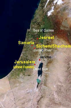
Map with
Shechem, Samaria, Jezreel, and Jerusalem. For
Jerusalem there are no findings.
|
Northern city state Shechem (later
"North Reich Israel") is a fully developed state with
strong relations to it's neighbors (p.178). City state
Shechem can have a free development now after the
Canaanite towns were destroyed, and Shechem can expand to
the bordering plains (p.181).
[Writings for Shechem are: Sichem, Sychem, Sechem, Salem,
in Greek and Latin Sikima, or Hebrew Shechem, with "Tell
Balata"].
The southern city state of Jerusalem (after the ruin of
the "North Reich Israel" came the rise to "South Reich
Judah") has hardly relations to it's neighbors because of
the geographic conditions with steep slopes and the Dead
Sea (p.178). In souther city state Jerusalem shepherd life
is going on with illiteracy and without any
administration, statal structure or army. By this, Shechem
and Jerusalem are not at all two "twin states" as it is
prescribed in the OT (p.181).
Common
characteristics of the city states of Shechem and
Jerusalem
-- in both territories is adored God JHWH besides other
gods
-- the populations have many common myths, heroes and
stories about the past
-- the populations have similar language and dialects of
Hebrew (p.178).
For the northern city state of Shechem the southern city
state of Jerusalem is a rural backcountry. And the
Canaanite city states in the plain and on the coast are
normally always more developed than Shechem (p.178).
[Considering their development there is the following
ranking: first come the coastal towns, then Shechem (later
with the capital of Samaria), and at the and comes the
South Reich Judah with Jerusalem].

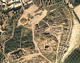
Sichem / Shechem: hill of ruins Tell Balata,
satellite photo
|
|
What tells archeology about
the city states of Shechem and Jerusalem of the 9th
century B.C.?
According to archeology, city state of Jerusalem - named
"Judah" in the Bible - has only little population during
10th and 9th century (p.176) and has hardly 20 villages
(p.177).
City state of Shechem - named "North Reich Israel" in the
Bible - has a dense population with differentiated
population structure, from big regional centers to little
hamlets, with an economic "growth" (p.177).
Shechem's commerce during the early 9th century B.C. with
it's neighbor regions leads to growth,
-- so there come regional fortified administration centers
-- so there can be built great palaces of blocks of stone,
for example with stony capitals, for example in Megiddo,
in Jezreel, and in the capital Samaria (p.177).
Around 900 B.C. city state of Shechem (later "North Reich
Israel") has got a full administration apparatus and a
social stratification. In it's commerce luxury is handled.
And luxury architecture is completing the picture of
"representation" (p.177).
Amun-temple in Karnak, outer front
Amun-temple in Karnak, columns with inscriptions


