from: Israel Finkelstein /
Neil A. Silberman: The Bible unearthed.
Archeology's New Vision of Ancient Israel and the Origin
of Its Sacred Texts; The Free Press, a division of Simon
& Schuster, Inc., 2001; German edition has got the
title "No trombones before Jericho" (orig. German:
"Keine Posaunen vor Jericho"): edition C.H.Beck oHG,
Munich 2002;
Here in this analysis is used the
German version "Keine Posaunen vor Jericho" of DTV,
Munich 2004, second edition of 2005. All page
indications refer to the German version. I hope the page
numbers are not very different.
The
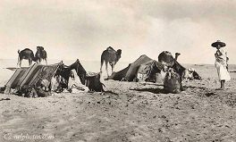
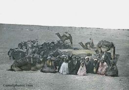
oval principle of villages coming from the tent camps of
the Bedouins

 Tents of Bedouins in 1915
 |

 Bedouins: rest in an oval
order Bedouins: rest in an oval
order |
According to the archaeologists the
first villages in the interval period between Middle and
Mid East have the form of an oval ring. The houses touch
each other, and the big inner courtyard seems having been
a protection from thieves for the herds of animals in the
night (p.127). Archaeologists can find only a few silos,
few blades of sickles, and only few grindstones for corn
cultivation (p.127-128).
Villages in an oval order also exist in
the mountains of the Westbank and in the South of the
Negev mountains. So, such villages not at all were a
single case (p.128), but oval order of villages had a
tradition in the whole Middle East and can be found in all
epochs:
-- in Sinai
-- in Jordan
-- in other regions of Middle East
(p.128).
This oval order of villages is typical
for villages in the mountains in regions bordering to
deserts. The construction in an oval form is similar to
the tent camps of the Bedouins placing their tents in an
oval until today, with an open courtyard. Also the
dimension and the number of unities between oval
construction of villages and the tent camps of the
Bedouins is a similar one (p.128).
Finkelstein / Silverman come to the
conclusion that the oval villages probably were built by
shepherds when they needed a period of settling down when
keeping the herd in a protected courtyard during the night
had prior priority (p.129).
Development
from the oval tent camp to the oval village of stones
-- the shepherd nomads had to give up
their nomadic life at the eastern border of the region,
not far away from the desert
-- the shepherd nomads hat to give up a
part of their animals and had to cultivate the land with
agriculture
-- this change is going on yet with the
Bedouins of today, and the first built settlement is
always in an oval form
-- the position at the border of the
desert partly permits herds of animals and agriculture at
the same time (p.120).
Archeology
can state a repeating rhythm in Canaan
The excavations of many villages let
detect a cycles between settling down and nomad life
(p.130):
The cycles between
oval construction of villages and nomadism in
Canaan at the margin of the desert
|
| Epoch |
Date |
Main characteristics
|
| Early
Bronze Age |
3500-2200
B.C. appr. |
first
wave of settlement, with proofs for about 100
villages
|
Interim
period
|
2200-2000
B.C. |
crises,
most of the villages are given up |
Middle
Bronze Age
|
2000-1550
B.C. appr. |
second
wave of settlement, with proofs for about 220
villages
|
Late
Bronze Age
|
1550-1150
B.C. |
crises,
proofs for only about 25 villages |
| Iron
Age I |
1150-900
B.C. appr. |
third
wave of settlement, with proofs for about 250
villages
|
| Iron
Age II |
900-586
B.C. |
the
settlements are rising up to more than 500
villages (8th century B.C.)
|
|
|
(Finkelstein / Silberman: Posaunen
2001, edition 2004, p.130) |
Facts of archeology about the early oval
villages
-- the culture of the villages of the different epochs is
not very different (p.131)
-- the culture in the villages consists of agriculture
with a plow with a cattle before, according to the
environment conditions and the economic conditions, what
can be seen with the bones of the animals (p.132)
-- there is always cultivation of olives and vineyards
[according findings of seed and tools]
-- findings say that the wine is exported even to Egypt:
In Egypt pottery vessels with clay from the Canaanite
highlands are found, one time even with a seed of a grape
in it (p.131).
Times
with empty villages
When the villages are empty again, the population have
changed to be Bedouins again. Agriculture with cattle and
plow hardly exists in these times, but there exist above
all herds of sheep and goats. Cattle herds do not exist
because they are not enough movable in the crises years
(p.133).
The
reasons for the cycles
The change between nomadism and sedentarism with it's oval
villages is provoked by political, economic, or climatic
reasons. Bedouins are converting into village settlers, or
villages settlers take their flight from new taxes to the
desert to nomadism (p.133). When the political situation
is safe the Bedouins settle down building villages, and
when the situation is dangerous the village inhabitants
convert into Bedouins so they are left alone (p.133-134).
The last period of settlement with building of villages is
connected with a forming of identity which is called in
certain regions "Israel" (p.131).
[But in the Bible there is not one single indication of
this cycles...]
Structure of the village
population
The village population is parted into two parts:
-- one part is specialized in agriculture
-- another part is keeping on big herds [as half nomads]
(p.134).
In this system there is a mutual dependency of farmers and
shepherd nomads:
-- the monads are dependent on agriculture products from
the villages: nutrition supplement with corn is important
for life, or the Bedouins had to cultivate corn themselves
-- and the village population gets the meat from the
nomads, and milk and skins, but this is not important for
life (p.134).
Natural
separation of northern and southern region as precursors
for a North Reich Israel and a South Reich Judah
Every wave of settlement creates two
different societies in Mid East with two different areas of
settlement in the North and in the South, dependent from the
topographic conditions. The border line of these two types
of settlement areas correspond more or less to the
territories of the later invented kingdoms of the North
(Israel) and South (Judah) in OT (p.171).
Northern region of settlement

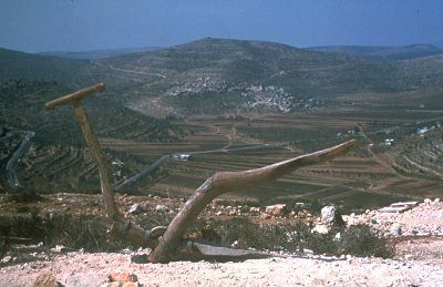
Northern region: soft hills in Jezreel plain
|
Southern
region of settlement

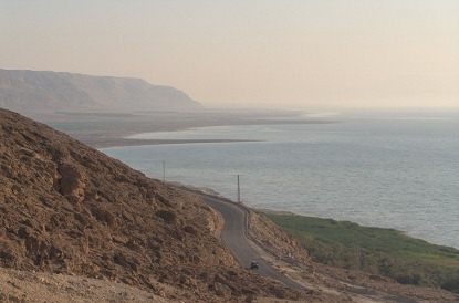
Southern region: Dead Sea with steep coast
|
Early Bronze Age
-- one place is the center of the government
with a religious center Tell el-Far'a, with a
big spring of fresh water, later known in the
Bible as Thirza, which is said having been the
first capital of the North Reich (p.172)
|
Early Bronze Age
-- the territory mainly is not very populated,
the population are shepherds of sheep and by
farmers (p.12)
-- up to 8th century B.C. Judah is very isolated
and only has little population, and reading and
writing are hardly distributed (p.56)
-- the region stays with only little population,
for example the places only have potsherds
without buildings indicating that these were
places for shepherds, all in all the territory
is about 50 ha in these times (p.172)
|
Middle Bronze Age
(2000-1550 B.C.)
-- the landscape has a dense population with
settled down farmers (p.172)
|
Middle Bronze Age
(2000-1550 B.C.)
-- populated villages are rare
-- there is a big number of shepherd groups with
cemeteries offside the populated villages
-- second center becomes Hebron which is also
well fortified and has got great temples
(excavation site is Tell Balata) (p.172)
|
Iron Age I in the
North (1150-900 B.C. appr.)
-- there is a great wealth and military power
-- reading and writing are well spread (p.56)
-- there is a dense population in big, middle
and little settlements (p.172)
|
Iron Age I in the
South (1150-900 B.C. appr.)
[slow development] |
Iron Age II in the
North
-- reading and writing are widespread, also
bureaucracy and administration, a professional
army, wealth and luxury, specialized industries
(p.233)
-- there come provocations against Assyria and
then ruin by the Assyrian occupation 720 B.C.
|
Iron Age II in the
South
-- Arab trade with the camel caravans from
southern Arabia is coming with trade of spices
and incense, that is a significant economic
factor for the kingdom of Judah since 8th / 7th
century B.C. (p.53)
-- after the destruction of the North Reich
Judah is developing impressive fortresses and
monumental temples and governments (p.172).
|
|
Finkelstein / Silberman: Posaunen
2001, edition of 2004
|
Documents
from abroad about Israel Palestine during Mid Bronze Age
(2000-1550 B.C. appr.)
19th century B.C.
Inscription
about the Egypt military campaign under leadership of
Khu-Sebek - mentioning of a center Shechem
There
is an inscription which archaeologists are dating in the
time of Pharaoh Sesostris III (1878-1843 B.C.). This
inscription describes an Egypt military campaign under
Khu-Sebek up to the highlands of Canaan, Egypt name is
"Retenu". The land Shechem is mentioned which is mentioned
in an equal manner like "Retenu". So, Shechem in these
times has having been a significant Jewish center in these
times already (p.173).
There is no other information in Egypt
Pharaoh's inscriptions about Canaan (p.173).
16th century B.C.
Facts of
archeology indicate: The agricultural sector has
impoverished
Latest
investigations indicate that the agricultural sector has
impoverished in 16th century B.C. already (p.120).
Data from abroad in the Late Bronze Age
(1550-1150 B.C.)
The documents say: There was
a geographic split between northern and southern states
In these times Canaan is often mentioned
in Egypt texts, for example in the letters of Tell
el-Amarna (14th century B.C.) (p.173). In these letters
already is stated the partition of the highlands of the
West Bank in two city states respectively in two separated
territorial areas Shechem and Jerusalem with 2,590 km2
each,
-- with king Abdi-Hepa in Jerusalem
(stands in the Bible always for "South Reich Judah")
-- with king Labaya in Shechem (stands
in the Bible always for "North Reich Israel") (p.173).
Within the split city states of Canaan
Jerusalem and Shechem are the biggest statal unities in
the Late Bronze Age, but the populations are less than the
dense populations in the little city states of the coastal
plain (p.173).
The conditions for the
development of the city states of Jerusalem and Shechem
Geographic conditions are very different
for the city states Shechem in the North and for Jerusalem
in the South. Bible claims later in OT a political
"split", but this split always had been in an natural way
and never was executed politically (p.175).
Development of the city state of
Shechem (in the Bible "Israel")
|
Development of the city state of
Jerusalem (in the Bible "Judah") |
- there are no big differences of
altitude on the way to the East, transports and
communication to the East are easily possible
- the area of Shechem partly consists of fertile
farmland which is enough for the own nutrition
- in the plains cultivation of corn is possible,
in the highlands is possible the cultivation of
olives and wine
-- by the favorable transport channels and the
own nutrition the North Reich has got a great
economic potential (p.175)
|
- on the way to the East there are
big differences of altitude, and the Dead Sea
has to be crossed, and all this makes transports
and communication to the East very difficult
resp. practically impossible
- the territory of the city state of Jerusalem
consists of dry and cliffy desert steps, and by
this an own nutrition with agriculture is hardly
possible
- by these bad conditions the economic potential
of the city state of Jerusalem is very little
(p.175)
|
- Shechem has great resources
- the sloped to the West are not very steep and
stony, so terrace agriculture with olive trees
and vines is well possible (p.176)
|
- Jerusalem hardly has resources
- the slopes are very steep and stony, so
terrace agriculture with olives and vines is
hardly possible (p.176)
|
-> with the possibilities of
transports between the city state of Shechem and
his neighbors are created markets, exchange of
products, commerce e.g. with corn, animal
products, and there are exports down up to Egypt
to the coastal markets
-> city state of Shechem can develop a
specialized economy (p.176)
-> northern highlands are populated from the
West in early times (p.177).
|
-> city state of Jerusalem
remains without possibility of transport and
without agriculture
-> city state of Jerusalem develops only
little markets and no exchange of products
-> the society in the city state of Jerusalem
stays monotonous, poor and has only little
growth of population (p.176)
-> southern highlands are populated from the
West only late (p.177).
|
|
Finkelstein / Silberman: Posaunen
2001, edition 2004 |
The distinction in a northern and a
southern state is happening by natural reasons. There is no
proof of a political split in the documents or indicated by
findings. The South is never a leading power against the
North as it is claimed later in OT with the invented kings
David and Solomon for Jerusalem (p.176).
[South Reich Judah with Jerusalem only
develops it's power when the North Reich Israel is destroyed
from the outside].
Tents of Bedouins in 1915


